Introduction to LiDAR technology
Anh Vũ Võ
Outline
- Week 1
- LiDAR technology
- Brief introduction to CloudCompare and PDAL
Preparation for Week 2 - Terrestrial LiDAR scanning demonstration
- Week 2
- LiDAR's applications and uses
- LiDAR data
- LiDAR data visualization and processing
with CloudCompare and PDAL
LiDAR 's applications and uses
USGS's 3D Elevation Program (3DEP)
- USGS's 3DEP: complete LiDAR coverage for the entire country by 2023
- Total project cost: $ 1 billion
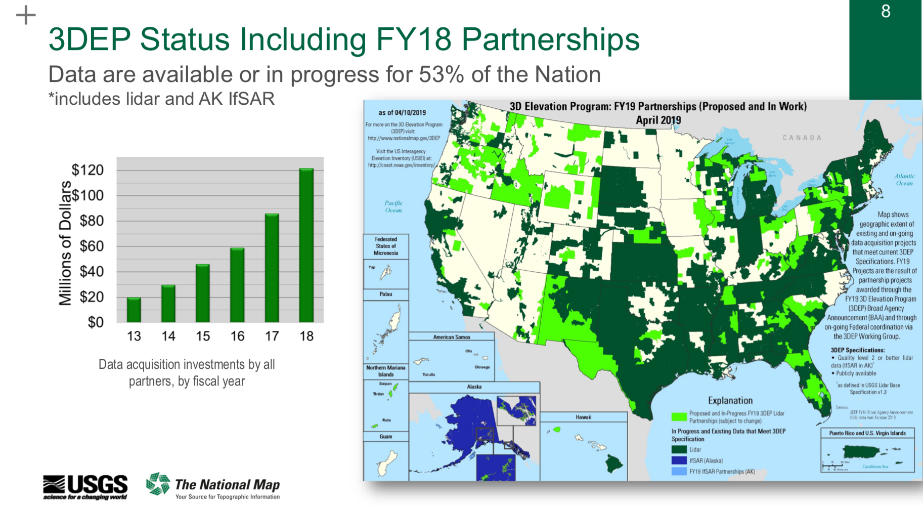
USGS's 3D Elevation Program (3DEP)
- USGS identified 600 applications potentially benefit from 3DEP data

USGS's 3D Elevation Program (3DEP)
- USGS identified 600 applications potentially benefit from 3DEP data
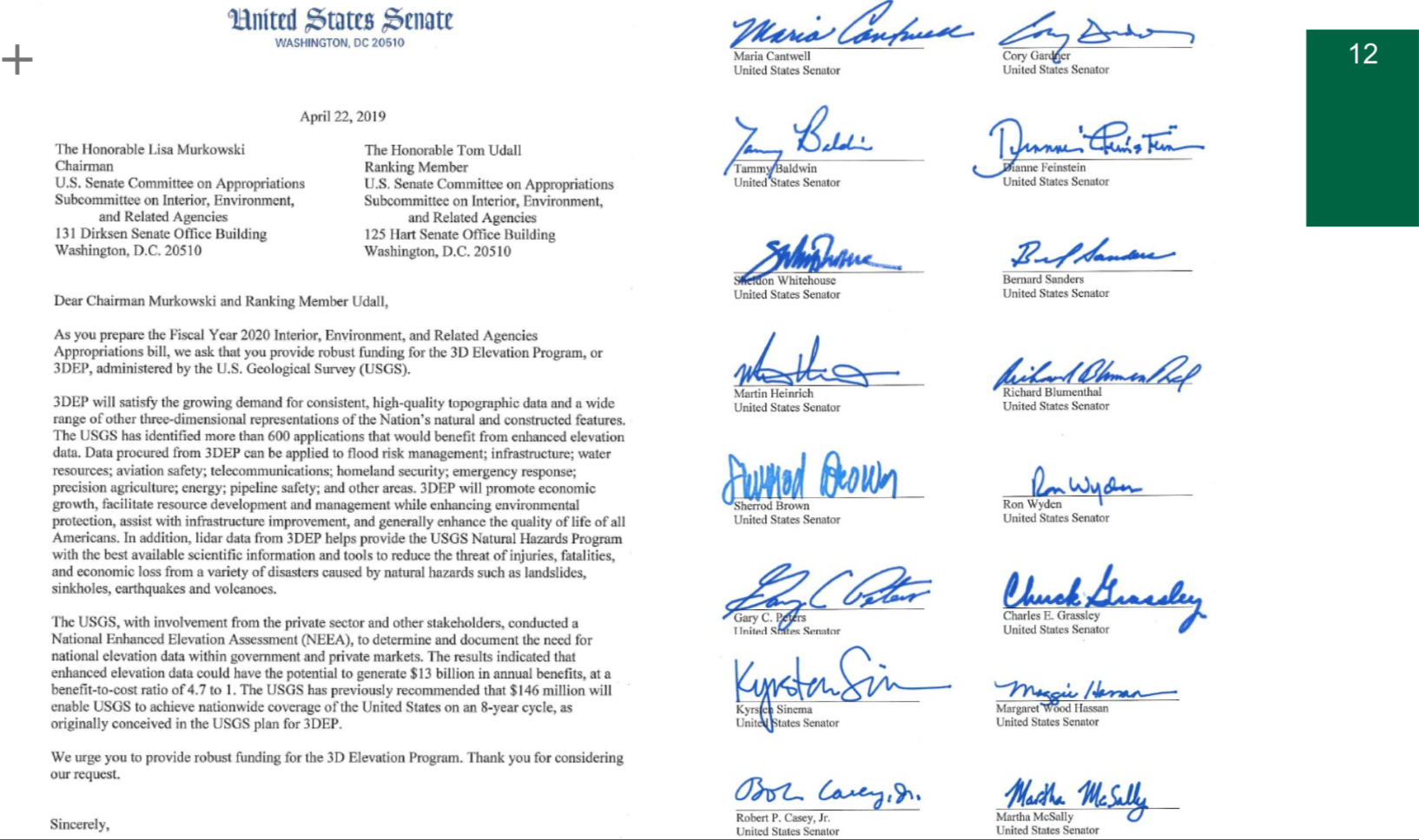
Business uses of LiDAR data (ordered by estimated annual benefits)
- Flood risk management (FEMA)
- Infrastructure and construction management
- Natural resources conservation (NEON)
- Agriculture and precision farming
- Water supply and quality
- Wildfire management, planning and response
- Geologic resource assessment and hazard mitigation
- Forest resources management
- River and stream resource management
- Aviation navigation and safety
- ...
- Land navigation and safety
Source: USGS Updates on 3DEP (April 24 2019) LiDAR applications and business uses factsheets
LiDAR data
a brief look under the hood
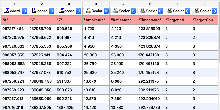
- LiDAR datasets are often referred to as "3D point clouds" - sets of spatially coherent, 3D points.
- In its simplest form, a LiDAR point cloud is a table of coordinates and numeric values, in which each row (tuple) contains the 3 coordinates of each sampling point (x, y, z) and optionally several additional point attributes.
LiDAR data
a brief look under the hood
- There are 2 types of point attributes: scalar (one-dimensional), and vector (multi-dimensional)
- Examples of additional attributes:
- Timestamp: a time tag value at which the point was acquired
- Intensity, reflectance, amplitude: a numeric value representing the (normalized) laser pulse return magnitude
- Number of returns (target count): the total number returns for a given pulse
- Return number (target ID): the pulse return number for a given output pulse
- True color: often in (red, green, blue) format
- Surface normal vector: often in (nx, ny, nz) format
LiDAR data in text formats
- Human readable and highly interoperable
- Not optimal for machine interpretation and manipulation.
- Generic CSV (comma-separated-values), TSV (tab-separated-values) formats can be used to store LiDAR data.
- Metadata (e.g. total number of points) can be stored in the beginning and/or the end of each file.
LiDAR data in binary formats
- Not human readable, and requires file format specification for interoperability
- Optimized for machine interpretation and often more compact
- Examples: LAS, E57
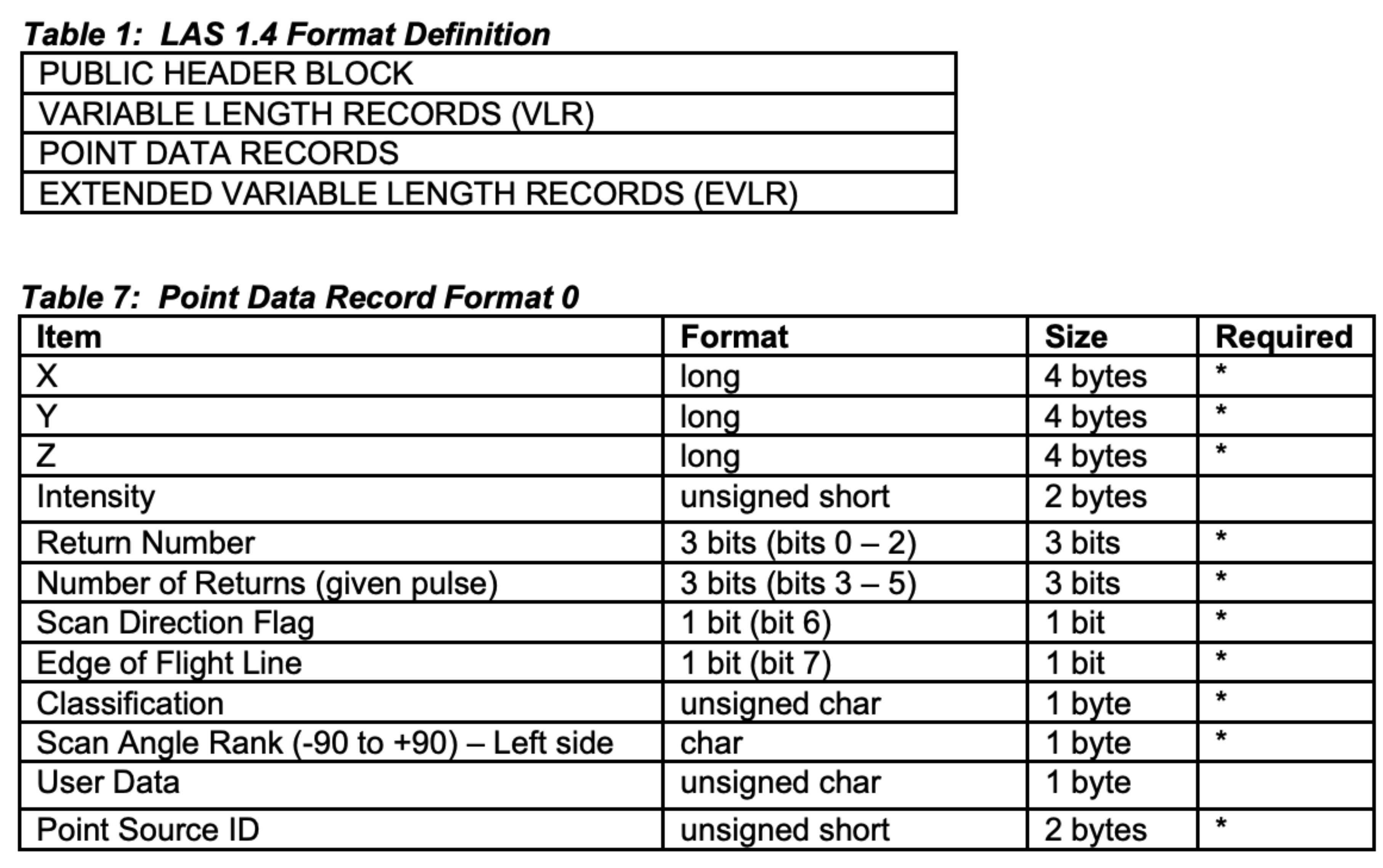
ASPRS's LAS format
- A standard file format developed and maintained by the ASPRS (American Society of Photogrammetry and Remote Sensing)
- General structure:
- Metadata (header and variable length records)
- Sequence of point records
- Additional metadata
ASPRS's LAS format
- A standard file format developed and maintained by the ASPRS (American Society of Photogrammetry and Remote Sensing)
Think twice (or more) about your selection of a data representation
- Be concious about the number of decimal digits you keep.
Think twice (or more) about your selection of a data representation
- Beware of the limitations of your selection of data types (e.g. IEEE 754 floating point number encoding).
- Not every real number can be represented by a IEEE 754 float.
- There is always a gap between 2 consecutive representable numbers. The gap increases as we move away from number zero.
- Example 1: the next representable float number after 0.085000000894070 is 0.085000008344650; there is a gap of 0.000000007450581 between the two numbers.
- Example 2: the next representable float number after 182536128.0 is 182536192.0; there is a gap of 64.0 between the two numbers.
Think twice (or more) about your selection of a data representation
- Beware of the limitations of your selection of data types (e.g. IEEE 754 floating point number encoding).
- "95% of folks out there are completely clueless about floating-point." -- James Gosling
- The first launch of Arian 5 (European space rocket) failed because of a similar problem.